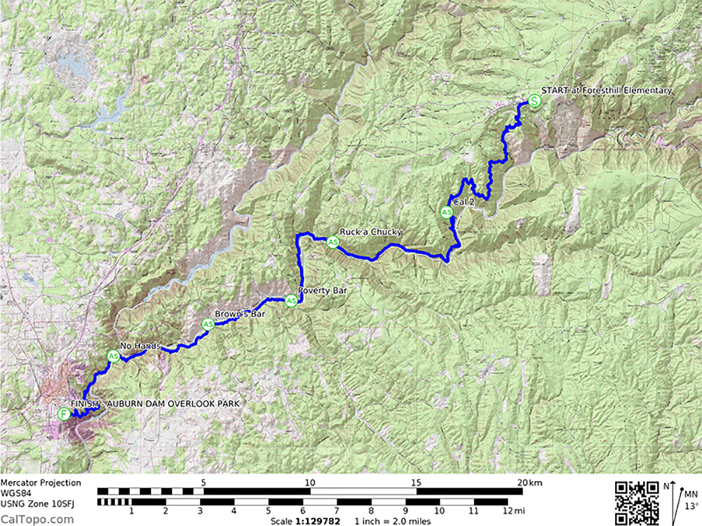
Course Description:
Due to on-going property access along Cal Street, we will start the 50k at Driver's Flat this year, the route will go up to Cal2 to turn around and then continue on the original route from Rucky Chucky and continues along the Middle Fork of the American River on the Tevis Cup and Western States trails before crossing the river at Poverty Bar. The 50K continues on Quarry Rd then across No Hands Bridge, and finishing in Auburn at the American River Canyon Overlook Park (Auburn Dam Overlook).
Start Time:
The 50K start time is 7:30 am.
Shuttle:
Shuttles to the start-line at the old Foresthill Elementary School will leave Auburn/Overlook Park at 6:30am for the 50K race. Tickets for the shuttle are available with registration.
Elevation Profile

Aid Stations:

Crews are welcome to support runners. Due to aid station locations, some crew access requires foot travel from 1 to 2 miles. Crews are permitted at the following aid stations: Rucky Chucky (foot access only, 2 miles one way), No Hands Bridge and the finish at Auburn Overlook.
Aid Station Directions: Provided below are crew driving directions to aid stations from the start at the old Foresthill Elementary School. Mileage is approximate, your distance may vary. Some aid stations require hiking 1-2 miles along unpaved, rough roads, or trails. Access aid stations at your own risk.
Rucky Chucky
West on Foresthill Rd – 9 miles
Left on Drivers Flat Rd – 0.4 miles
- Park in Drivers Flat Staging Area
- Parking Fee Required
- Hike down dirt road on left to Rucky Chucky – 2 miles
No Hands Bridge
Drive up Drivers Flat Rd – 0.4 miles
Left on Foresthill Rd – 4.5 miles
Left on Old Auburn Foresthill Rd – 3.2 miles
Left on CA-49 – 3.4 miles
- Park along west side of CA 49 after crossing bridge
- Hike on dirt road to No Hands Bridge approximately 0.1 miles
From Auburn State Recreational Area - “Black Hole of Calcutta Falls Trailhead” (No Hands Bridge Aid Station) to Finish Line-
Auburn Overlook Park (840 Pacific Avenue)
From the parking area: Drive 500 ft over the bridge and turn left onto HWY 49/El Dorado St.
Drive 2.8 miles (northwest) on HWY 49/El Dorado St. and continue on High St for 0.3 miles.
Turn left onto Pleasant Avenue and drive 1/2 mile. Pleasant Ave turns slightly left and becomes Pacific Ave. Auburn Overlook Park is on your left.